Hurricane Impact Report* for
* Sample only (actual values will differ)
|
|
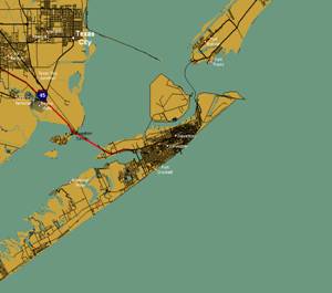
Location
Characteristics:
Wind Impact
The following report indicates the estimated maximum wind speeds experienced at this specific location from 1851-2002 due to tropical cyclones.
|
Category
of Wind (Safir Simpson Scale) |
Damage
* |
Occurrences by Wind Category |
Chance of occurrence of category
wind or greater, per year |
Period occurrence (every x years) |
|
0:
30-63 knots |
Minor |
55 |
47% |
Every 2.1 years |
|
1: 64-82
knots |
Minimal |
12 |
11% |
9 years |
|
2: 83-95
knots |
Moderate |
1 |
3.3% |
30 years |
|
3: 96-113
knots |
Extensive |
2 |
2.6% |
39 years |
|
4:
114-134 knots |
Extreme |
2 |
1.3% |
77 years |
|
5: 135+
knots |
Catastrophic |
0 |
- |
- |
|
|
|
|
|
|
The
highest wind speeds experienced since 1851 was 119 knots (137 mph) with gust to
137 knots (157 mph).
These statistics
indicate a location that is prone to experience an above average number of
storms. Although the vast majority of
the winds experienced by these storms are category 1 or less, there have been 4
that have caused extensive to extreme damage.
See detailed description of Category Wind Damage
at the end of this report.
Storm Surge Potential
Being situated along the
Storm Surge Inundation Report:
The report below indicates the maximum storm surge flooding at this
specific location for each category of storm.
|
Location |
Elev. (ft) |
Cat 1 Inund. AGL (ft) |
Cat 2 Inund. AGL (ft) |
Cat 3 Inund. AGL(ft) |
Cat 4 Inund. AGL(ft) |
Cat 5 Inund. AGL(ft) |
|
|
6 |
2.0 |
3.5 |
7.4 |
11.0 |
13.7 |
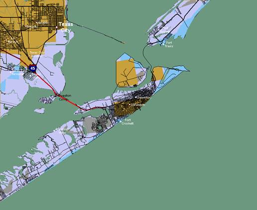
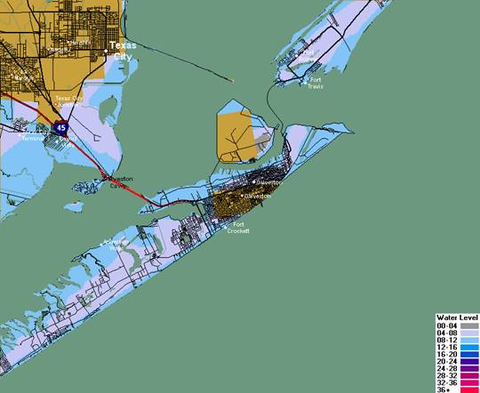
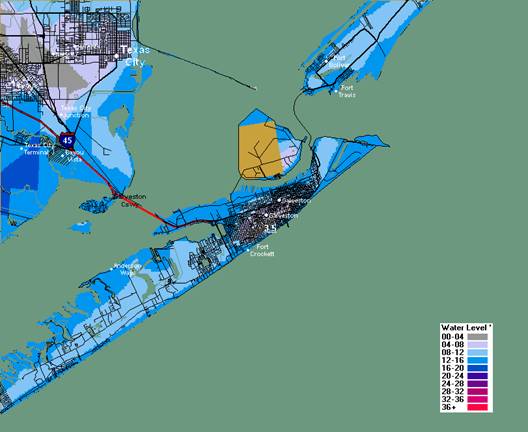
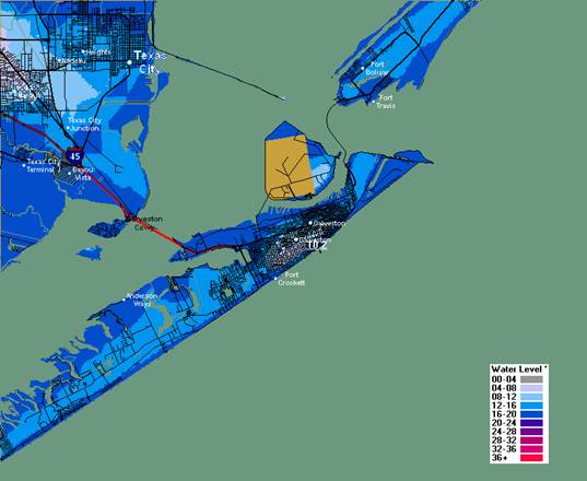
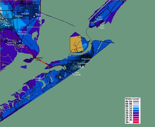
Storm Surge Inundation Maps:
The maps indicate the maximum areas of storm surge flooding for each
location on the map. I.E. since some
areas of the map may experience the highest flooding with wind from a certain
direction and other areas experience the highest flooding with winds from a
difference direction, you would never see a pattern of flooding as represented
by the image.
Category 1
Category 2
Category 3
Category 4
Category 5
*
Detailed description of
Category 1 -5 wind damage.
Category
One Hurricane:
Winds 74-95 mph (64-82 kt or 119-153 km/hr). Storm surge
generally 4-5 ft above normal. No real damage to building structures. Damage primarily to unanchored mobile homes, shrubbery, and trees.
Some damage to poorly constructed signs. Also, some coastal road flooding and
minor pier damage
Category
Two Hurricane:
Winds 96-110 mph (83-95 kt or 154-177 km/hr). Storm surge
generally 6-8 feet above normal. Some roofing material, door, and window
damage of buildings. Considerable damage to shrubbery and
trees with some trees blown down. Considerable damage to mobile homes,
poorly constructed signs, and piers. Coastal and low-lying escape routes flood
2-4 hours before arrival of the hurricane center. Small craft in unprotected
anchorages break moorings
Category
Three Hurricane:
Winds 111-130 mph (96-113 kt or 178-209
km/hr). Storm surge generally 9-12 ft above normal. Some structural damage to small residences and utility buildings
with a minor amount of curtain wall failures. Damage
to shrubbery and trees with foliage blown off trees and large trees blown down.
Mobile homes and poorly constructed signs are destroyed. Low-lying escape
routes are cut by rising water 3-5 hours before arrival of the center of the
hurricane. Flooding near the coast destroys smaller structures with larger
structures damaged by battering from floating debris. Terrain
continuously lower than 5 ft above mean sea level may be flooded inland 8 miles
(13 km) or more. Evacuation of low-lying residences with several blocks
of the shoreline may be required
Category
Four Hurricane:
Winds 131-155 mph (114-135 kt or 210-249
km/hr). Storm surge generally 13-18 ft above normal. More extensive
curtain wall failures with some complete roof structure failures on small
residences. Shrubs, trees, and all signs are blown down. Complete destruction
of mobile homes. Extensive damage to doors and windows.
Low-lying escape routes may be cut by rising water 3-5 hours before arrival of
the center of the hurricane. Major damage to lower floors of
structures near the shore. Terrain lower than 10 ft
above sea level may be flooded requiring massive evacuation of residential
areas as far inland as 6 miles (10 km).
Category Five Hurricane:
Winds greater than 155 mph (135 kt or 249 km/hr). Storm surge generally greater than 18 ft
above normal. Complete roof failure on many residences and industrial
buildings. Some complete building failures with small utility buildings blown
over or away. All shrubs, trees, and signs blown down.
Complete destruction of mobile homes. Severe and extensive
window and door damage. Low-lying escape routes are cut by rising water
3-5 hours before arrival of the center of the hurricane. Major damage to lower
floors of all structures located less than 15 ft above sea level and within 500
yards of the shoreline. Massive evacuation of residential areas on low ground within
5-10 miles (8-16 km) of the shoreline may be required