"ExpertEase"
– Our highly rated
ExpertEase, will
continue in the 2015
software with one important
change: it
includes the
Winter and Spring
months, making it a
year round benefit. Please
note that this feature is
ONLY available to users who
maintain the current version
of the Hurrtrak software. In
order to continue receiving
these updates, you need to
upgrade to the 2015
software. For those less
familiar with this feature,
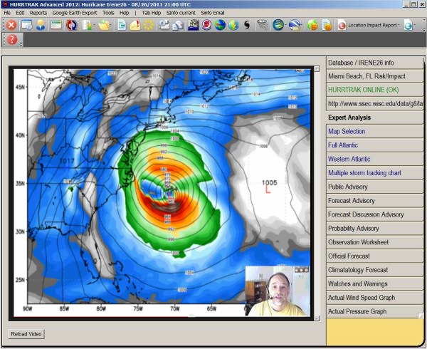
ExpertEase provides another
tool in your data arsenal.
On a daily basis, our chief
meteorologist discusses via
video update, current
tropical (and now also
non-tropical) conditions as
well as what is likely to
occur in the near term. His
observations are integrated
within the Hurrtrak program
throughout the Atlantic
Hurricane season and
available via a web browser
in the off-season. Unique to
PC Weather Products
portfolio, ExpertEase gives
you “inside” knowledge of
the factors and conditions
affecting the path and
strength of active tropical
storms and/or the tropical
season in general. Remember,
it is available to all users
with current Hurrtrak
software installed and now
includes
winter and spring
weather.
Forecast Trend added to
impact reports
- A significant enhancement
this year is the addition of
a new report field…
forecast wind trend.
It indicates the change in a
location’s forecast wind
from the prior forecast
advisory and is extremely
helpful in quantifying the
effect of a newly released
forecast from the National
Hurricane Center (or JTWC).
This information will be
included on all location
impact type reports as well
as the risk analysis
function and the narrative
impact statement.
Enhanced wind estimation
(varying elevations)
- In addition to "tweaking"
the forecast/actual wind
estimation, a new feature
allows you to estimate winds
at different elevation
levels. For example, you can
estimate winds on top of a
high rise building or on top
of a rig vs. nearer ground
level. This is especially
useful if you need to
consider assets at
elevations other than 33
feet (the default for
the system).
Forecast Trend
thematic
- Related to the forecast
wind trend enhancement
mentioned above, we also
show the
Trend information in
a
county thematic format.
This allows the user to
quickly... and graphically
see the effects of a change
in the storm's forecast.
Click on the heading to see
an example with Hurricane
Charley in 2004.
Current Weather Observations
& Depiction
–
We have enhanced this
feature in 2015 by adding
the display and reporting of
Precipitation, Relative
Humidity and Heat Index.
This feature allows the user
to examine current
observations for all
official weather stations,
coastal NOAA operated
stations, Buoy, Oil Rig and
Ship Reports. The data
includes current weather,
wind speeds (of course),
wave heights, Pressure,
Ocean Temperatures, Air
Temperature, Dew Points,
Local storm reports… and now
precipitation, humidity and
heat index. This is all
presented in a user friendly
format including the
depiction of current
tropical cyclones and the
ability to plot graphically
the parameters mentioned
above. Sample uses of this
feature include:
• Comparison of forecast vs
actual developing conditions
• Easy, quick displays of
smaller scale events away
from the storm’s circulation
(i.e. feeder bands)
• Real time, multiple source
on-site reports, indicating
storm effects on the ground
• The ability to view local
(or worldwide) weather
observations, even without
active tropical storms
• Depiction of formation
"alert" areas
• and now...
real time
depiction of dangerous heat
indices, daily
precipitation
amounts and relative
humidity.
Usability improvements -
Several improvements have
been made to our system
including handling
situations where un-named
tropical depressions become
a named tropical storm.
Users need not remember to
open a new storm name.
Cross wind calculations
-
We have enhanced the system
for users who need to know
the onset of 25 knot
crosswinds as a storm
approaches as well as the
time of the last 25 knot
crosswind as it moves away.
This is particularly useful
for users involved with
airport/runway operations.
Enhanced Wind Probabilities
- For users of the
Global or Advanced software
we have
extended the wind
probability reporting and
display to the Western
Pacific.
Excel export enhancements
–
Excel export now includes
forecast wind trend data and the
additional observation data
information.
Risk Impact Summary Reports –
Automatic and
manual Risk Impact Reports
now include
forecast wind trend
information.
Narrative Impact Description
- The
narrative now includes
commentary on the
forecast wind trend for the
analyzed location.
SLOSH/Storm Surge
improvements
–
SLOSH basins which have been
updated will be rolled into
the 2015 release. As
of mid March, 2015 this
includes the following
basins, Chesapeake Bay, New
Orleans and other to be
determined.
Much
more detail along with
software improvements have
made the Storm Surge program
easier to use.
Enhanced Network Operations –
For Network version
customers, we have added
additional support to allow
the server process all
updates and automation (i.e. EMail Alerts).
This facilitates unmanned
24/7 processing and allows
workstation users to operate
the system in a more
efficient manner.
System Appearance –
We have added
a few more themes/skins to
give the application a
custom appearance.
and...
more changes
under development not
yet listed
here...